Seaholm Area Multimodal Connectivity
Seaholm Area Multimodal Connectivity
Thank you for visiting the virtual open house and survey offering alternatives to developing the space along Power Plant Drive and Third Street between West Avenue and Walter Seaholm Drive. The goal of this project is to improve the livability, connectivity, safety and comfort of people living in and moving through this area. We appreciate everyone who participated in the project survey and attended our pop-up event on March 1. The survey was open from February 19, 2025, to March 23, 2025. A Community Feedback Report will be shared in the coming weeks outlining the City's next steps based on the input received.
Overview
The City of Austin is developing five projects as part of an effort to improve connectivity to, from and within the Seaholm District with funding provided by the Austin City Council in December of 2023 through Ordinance No. 20231214-064.
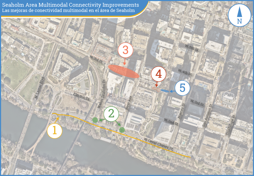
Map Legend:
Cesar Chavez Street sidewalk and trail improvements (Sandra Murida Way - San Antonio Street)
Trail crossings at West Avenue and Walter Seaholm Drive
Third Street and Power Plant Drive (West Avenue - Walter Seaholm Drive)
Improved North-South Shoal Creek Trail Alignment at Third Street
Improvements to the East-West Crossing of Shoal Creek at Third Street
The collection of projects includes:
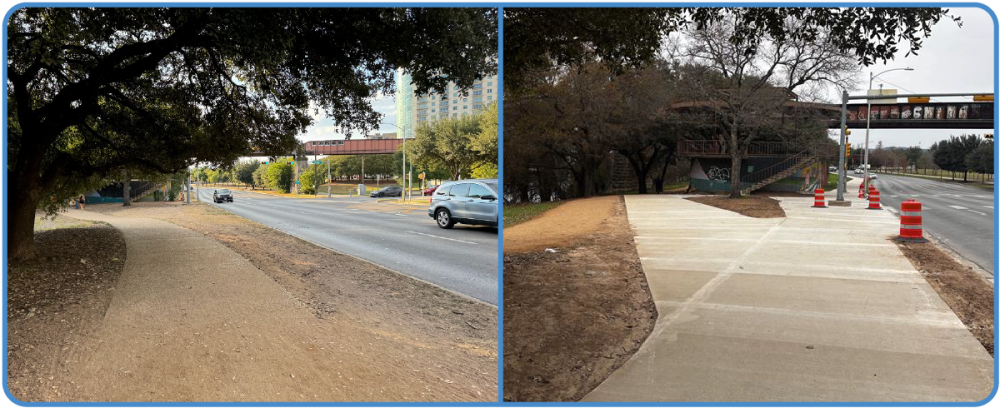
Improved trail and sidewalk connectivity along the south curb of Cesar Chavez Street. (in construction)
Improved crossing safety and West Avenue and Walter Seaholm Drive. (In construction)
Improvements to Third Street and Power Plant Drive, the subject of this community discussion
Improved alignment of the Shoal Creek Trail between Second Street and Fourth Street (options will be brought to the community for consideration in a future phase)
Improved east-west movement and placemaking across Shoal Creek (options will be brought to the community for consideration in a future phase)
Before (left) and after (right) photos of a new trail along the south curb of Cesar Chavez Street.
Market Plaza concept
In 2021, the Shoal Creek Conservancy published the Cyprus and Shoal Public Space Strategy which was a planning effort undertaken with the Downtown Austin Alliance (DAA) to propose improvements to safety, access and connectivity for people walking and bicycling in the vicinity of Shoal Creek and Third Street.
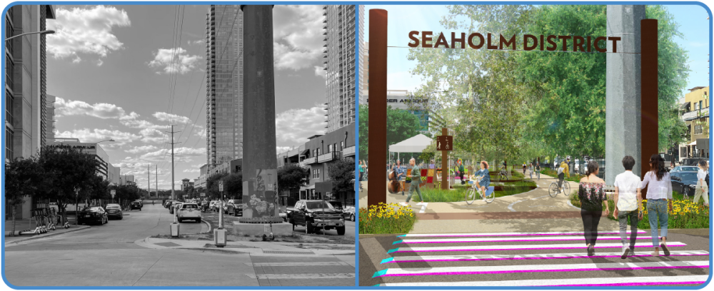
One of the seven ideas proposed included a Market Plaza concept that identified the need for safer intersections, more intuitive paths of travel east and west, and improved public space between West Avenue and Walter Seaholm Drive.
The study also identified concerns about impacts to the area retail shops and restaurants regarding on-street parking. In discussions with the City since the study was published, property owners in the area have reiterated these concerns and provided feedback on the frequency of deliveries for residents and retailers, which can happen daily, sometimes more often.
As a result, the City has come up with four alternatives for transforming this unique public space and requests community feedback.
Existing condition (left) and a conceptual drawing from the Cyprus and Shoal Public Space Strategy (right)
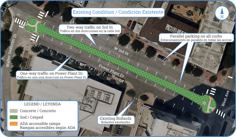
Existing Condition
Currently, the space between Walter Seaholm Drive and West Avenue consists of two parallel streets, Power Plant Drive and Third Street, separated by a median, with on-street parking on both sides of each street.
Existing conditions drawing
Alternative 1: Full plaza
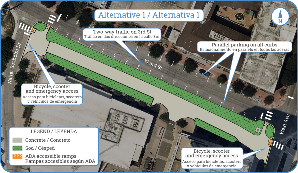
Alternative 1 offers a plaza space with wide planted areas on both sides. This alternative would require closure of Power Plant Drive and removal of approximately 29 parking spaces. Emergency access would remain via removable bollards. The connections on the east and west extents would be designed to support more intuitive and attractive crossings of West Avenue and Walter Seaholm Drive. The newly established Market Plaza would connect with the existing plaza to the south, flanked by the interior facing restaurants and retailers.
Alternative 1: Full Plaza with on-street parking on Third Street
Alternative 2: Plaza with back-in angle parking
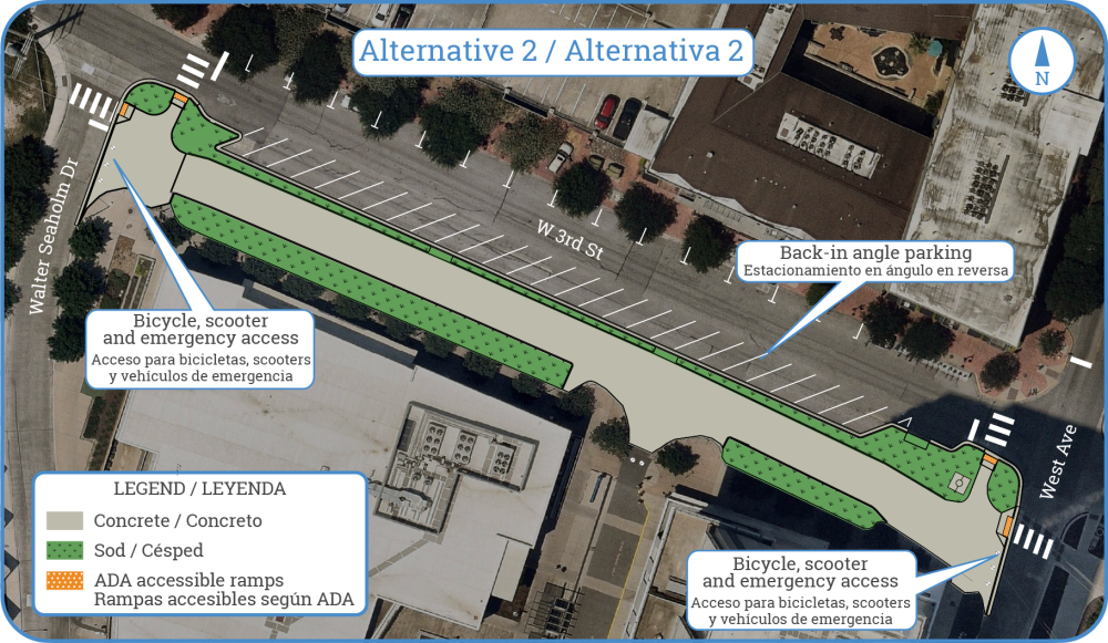
Alternative 2 offers a plaza with back-in angled parking, similar to areas such as South Congress Avenue and Dean Keeton Street. Power Plant Drive would be closed, and 29 parking spaces would be removed, but the back-in angle parking along the south curb of Third Street would provide another 10 spaces than it does now, for a net loss of 19 spaces. As with Alternative 1, emergency access would remain via removable bollards and the connections east and west would be designed to support more intuitive and attractive crossings of West Avenue and Walter Seaholm Drive.
Alternative 2: Plaza with back-in angle parking
Alternative 3: Trail connection without plaza
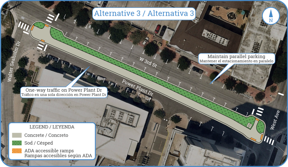
Alternative 3 offers an urban trail between Power Plant Drive and Third Street but keeps Power Plant Drive open, with parking removed from the north curb and remaining on the south curb, a net loss of 18 spaces. The connections east and west would be designed to support more intuitive and attractive crossings of West Avenue and Walter Seaholm Drive.
Alternative 3: Trail connection without plaza
Alternative 4: Full plaza with delivery access
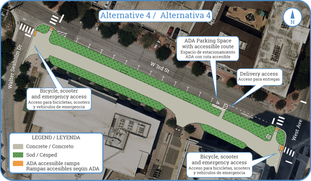
Alternative 4 offers a plaza space with slightly narrowed planted area on the north side to make room for a commercial loading zone and an ADA accessible parking spot. As with Alternative 1 and 2, Power Plant Drive would be closed and 29 parking spaces would be removed, with an additional 4 spaces to be used for a commercial loading zone along the south curb of Third Street to support deliveries. Emergency access would remain via removable bollards and the connections east and west would be designed to support more intuitive and attractive crossings of West Avenue and Walter Seaholm Drive.
Alternative 4: Plaza with commercial delivery zone and ADA accessible parking spot
Next Steps
Community feedback was gathered between February 19 and March 23, 2025. A report will be prepared in the coming weeks to reflect these comments and a selected alternative.
For questions, to optain a copy of the report or to sign up as a project stakeholder, email MobilityBonds@AustinTexas.gov or call 512-974-2300.
